carta de aproximacion visual no oficial aerodromo de
Anuncio
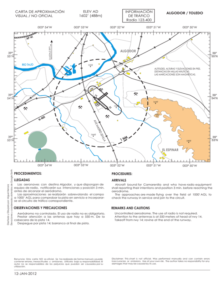
CARTA DE APROXIMACIÓN VISUAL / NO OFICIAL 003° 54’W ELEV AD 1602’ (488m) 003° 53’W INFORMACIÓN DE TRÁFICO Radio 123.400 003° 52’W ALGODOR / TOLEDO 003° 51’W 003° 50’W 1 AP-4 VAR 2°W(2010) 39° 55’N RIO TAJO ALGODOR 39° 55’N 1522 ALTITUDES, ALTURAS Y ELEVACIONES EN PIES. DISTANCIAS EN MILLAS NÁUTICAS. LAS MARCACIONES SON MAGNÉTICAS. 14 39° 54’N 1649 H 32 160 39° 54’N 0 1540 1682 AVE 00 N-4 LLA EVI D-S DRI MA 1660 39° 53’N M 1N 1809 39° 53’N EL ESPINAR Diseñado y Dibujado por: Miguel Herranz Elevaciones y coordenadas obtenidas de Google Earth 003° 54’W 003° 53’W 003° 52’W 003° 51’W 003° 50’W PROCEDIMIENTOS: PROCEDURES: LLEGADAS ARRIVALS Las aeronaves con destino Algodor, y que dispongan de equipo de radio, notificarán sus intenciones y posición 3 min. antes de alcanzar el aeródromo. Las aproximaciones se realizarán sobrevolando el campo a 1000’ AGL para comprobar la pista en servicio e incorporarse al circuito de tráfico correspondiente. Aircraft bound for Camarenilla and who have radio equipment shall reporting their intentions and position 3 min. before reaching the aerodrome. The approaches are made flying over the field at 1000' AGL to check the runway in service and join to the circuit. OBSERVACIONES Y PRECAUCIONES REMARKS AND CAUTIONS Aeródromo no controlado. El uso de radio no es obligatorio. Prestar atención a las antenas que hay a 550 m. De la cabecera de la pista 14. Despegue por pista 14; barranco al final de pista. Renuncia: Esta carta NO es oficial. Se ha realizado de forma manual y puede contener errores, inexactitudes u omisiones. Utilícela bajo su responsabilidad. El autor no se responsabiliza de los perjuicios que puedan ser causados por su utilización. 12-JAN-2012 Uncontrolled aerodrome. The use of radio is not required. Attention to the antennas is at 550 meters of head of rwy 14. Takeoff from rwy 14; ravine at the end of the runway. Disclaimer: This chart is not official. Was performed manually and can contain errors inaccuracies or omissions. Use at your own risk. The author takes no responsibility for any damages that may be caused by its use. ADC - 12-JAN-2012 ESPAÑA PLANO DE AERÓDROMO NO OFICIAL 39°53’53’’N 003°52’27’’W INFORMACIÓN DE TRÁFICO Radio 123.400 ELEV 488 m ALGODOR / TOLEDO 23 ELEVACIONES Y DIMENSIONES EN METROS. LAS MARCACIONES SON MAGNÉTICAS. VAR 2°W(2010) 33 0x T 15 IER RA ELEV 524 14 05 PARKING DE VISITANTES MANGA H ARP HANGARES 20 0x 43 A O LT A SF 32 Diseñado y Dibujado por: Miguel Herranz ELEV 538 SERVICIOS DE AERÓDROMO El aeródromo de Algodor cuenta con escuela de vuelo de ULM. Se encuentra a 14Km de Toledo por la N-400 y junto a la vía del AVE Madrid-Sevilla. Jefe de vuelos: Info: Tlfn: 925 230 179 12-JAN-2012 AERODROME SERVICES The Algodor AD has flight school of ULM. It is located 14 Km from Toledo by the N-400 and beside the AVE Madrid-Seville railway. Aerodrome boss: Info: Tlfn: 925 230 179
