Evaluation notes were added to the output document
Anuncio
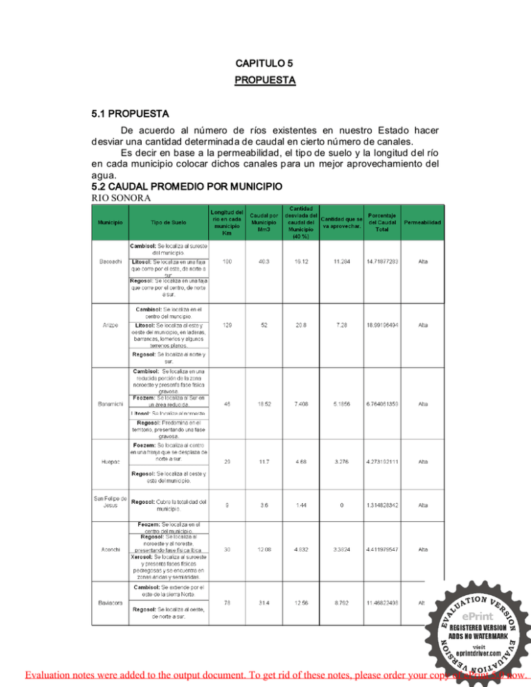
CAPITULO 5 PROPUESTA 5.1 PROPUESTA De acuerdo al número de ríos existentes en nuestro Estado hacer desviar una cantidad determinada de caudal en cierto número de canales. Es decir en base a la permeabilidad, el tipo de suelo y la longitud del río en cada municipio colocar dichos canales para un mejor aprovechamiento del agua. 5.2 CAUDAL PROMEDIO POR MUNICIPIO RIO SONORA 42 Evaluation notes were added to the output document. To get rid of these notes, please order your copy of ePrint 5.0 now. Tabla 14. Caudal promedio por municip io. Río Sonora RIO CONCEPCIÓN 43 Evaluation notes were added to the output document. To get rid of these notes, please order your copy of ePrint 5.0 now. Tabla 15. Caudal promedio por municip io Río Concepción. 44 Evaluation notes were added to the output document. To get rid of these notes, please order your copy of ePrint 5.0 now. RIO ALTAR Tabla 16. Caudal promedio por municip io Río Altar. 45 Evaluation notes were added to the output document. To get rid of these notes, please order your copy of ePrint 5.0 now. RIO YAQUI 46 Evaluation notes were added to the output document. To get rid of these notes, please order your copy of ePrint 5.0 now. Tabla 17. Caudal promedio por municipio. Río Yaqui. RIO BAVISPE 47 Evaluation notes were added to the output document. To get rid of these notes, please order your copy of ePrint 5.0 now. Tabla 18. Caudal promedio por municip io. Río Bavispe. 48 Evaluation notes were added to the output document. To get rid of these notes, please order your copy of ePrint 5.0 now. RIO MATAPE Tabla 19. Caudal promedio por municip io. Río Matape 49 Evaluation notes were added to the output document. To get rid of these notes, please order your copy of ePrint 5.0 now. RIO SAN MIGUEL 50 Evaluation notes were added to the output document. To get rid of these notes, please order your copy of ePrint 5.0 now. Tabla 20. Caudal promedio por municip io. Río San Miguel. Para elaborar las tablas anteriores Recurrimos al Mapa Turístico sonora de comunicaciones y Transportes con una escala de 1:750 000. de Obtuvimos la longitud del río en cada uno de los municipios por los que atraviesa. Es decir: Sacamos la Longitud del río en ese municipio. Y su respectivo caudal en base al caudal total anual del río. Así también se determino la cantidad que se desviará en cada municipio. Determinando un 40 % de agua desviada. 5.3 PROPUESTA DE DESVIACIÓN DE FLUJO POR RÍO Y MUNICIPIO. De acuerdo al porcentaje del caudal total desviado de acuerdo a la tabla 13. Y a la permeabilidad en cada uno de los municipios se hizo la propuesta de un determinado número de canales para cada municipio. Los cuáles son como sigue: OBSERVACIONES La Cantidad desviada es muy pequeña Debido al caudal desviado y su poca permeabilidad Debido al caudal desviado y permeabilidad del terreno Tabla 21. Numero de canales propuestos. NÚMERO DE CANALES 0 1-2 3-4 51 Evaluation notes were added to the output document. To get rid of these notes, please order your copy of ePrint 5.0 now. 5.3.1 Tabla de Propuesta de desviación de flujo por río y por municipio . RIO SONORA 52 Evaluation notes were added to the output document. To get rid of these notes, please order your copy of ePrint 5.0 now. Tabla 22. Propuesta de canales de desviación en Río Sonora. RIO CONCEPCIÓN 53 Evaluation notes were added to the output document. To get rid of these notes, please order your copy of ePrint 5.0 now. Tabla 23. Propuesta de canales de desviación en Río Concepción. RIO ALTAR 54 Evaluation notes were added to the output document. To get rid of these notes, please order your copy of ePrint 5.0 now. Tabla 24. Propuesta de canales de desviación en Río Altar RIO YAQUI 55 Evaluation notes were added to the output document. To get rid of these notes, please order your copy of ePrint 5.0 now. Tabla 25. Propuesta de canales de desviación en Río Y aqui. 56 Evaluation notes were added to the output document. To get rid of these notes, please order your copy of ePrint 5.0 now. RIO BAVISPE 57 Evaluation notes were added to the output document. To get rid of these notes, please order your copy of ePrint 5.0 now. Tabla 26. Propuesta de canales de desviación en Río Bavispe. RIO MATAPE 58 Evaluation notes were added to the output document. To get rid of these notes, please order your copy of ePrint 5.0 now. Tabla 27. Propuesta de canales de desviación en Río Matape RIO SAN MIGUEL 59 Evaluation notes were added to the output document. To get rid of these notes, please order your copy of ePrint 5.0 now. Tabla 28. Propuesta de canales de desviación en Río San Miguel. 60 Evaluation notes were added to the output document. To get rid of these notes, please order your copy of ePrint 5.0 now. 5.4 DIMENSIONES PROPUESTAS PARA LOS CANALES DE DESVIACIÓN. CANAL 1 2 3 a (m) 2 4 6 b (m) 2.309 2.309 2.309 c (m) 600 800 1000 Tabla 29. Dimensiones propuestas para los canales. Forma de los canales 20 cm Separación 2.309 m 600 m Varilla 3/8” 2m 61 Evaluation notes were added to the output document. To get rid of these notes, please order your copy of ePrint 5.0 now. 5.5 MATERIAL UTILIZADO PARA LA CONTRUCCIÓN DE LOS CANALES Cemento Arena Grava Concreto Mano de Obra Varilla Excavación Maquinaria 62 Evaluation notes were added to the output document. To get rid of these notes, please order your copy of ePrint 5.0 now.
