tiny new fish species discovered - Smithsonian Tropical Research
Anuncio

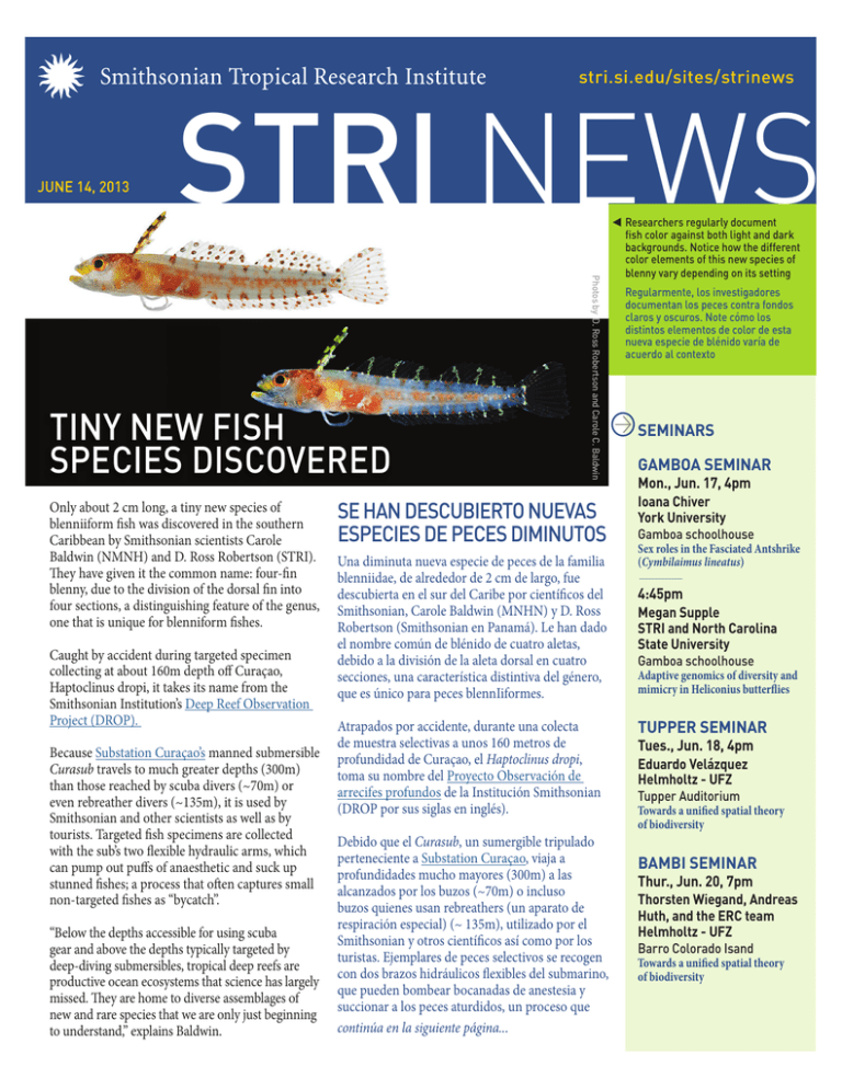
STRI NEWS stri.si.edu/sites/strinews JUNE 14, 2013 Only about 2 cm long, a tiny new species of blenniiform fish was discovered in the southern Caribbean by Smithsonian scientists Carole Baldwin (NMNH) and D. Ross Robertson (STRI). They have given it the common name: four-fin blenny, due to the division of the dorsal fin into four sections, a distinguishing feature of the genus, one that is unique for blenniform fishes. Caught by accident during targeted specimen collecting at about 160m depth off Curaçao, Haptoclinus dropi, it takes its name from the Smithsonian Institution’s Deep Reef Observation Project (DROP). Because Substation Curaçao’s manned submersible Curasub travels to much greater depths (300m) than those reached by scuba divers (~70m) or even rebreather divers (~135m), it is used by Smithsonian and other scientists as well as by tourists. Targeted fish specimens are collected with the sub’s two flexible hydraulic arms, which can pump out puffs of anaesthetic and suck up stunned fishes; a process that often captures small non-targeted fishes as “bycatch”. “Below the depths accessible for using scuba gear and above the depths typically targeted by deep-diving submersibles, tropical deep reefs are productive ocean ecosystems that science has largely missed. They are home to diverse assemblages of new and rare species that we are only just beginning to understand,” explains Baldwin. Photos by D. Ross Robertson and Carole C. Baldwin TINY NEW FISH SPECIES DISCOVERED SE HAN DESCUBIERTO NUEVAS ESPECIES DE PECES DIMINUTOS Una diminuta nueva especie de peces de la familia blenniidae, de alrededor de 2 cm de largo, fue descubierta en el sur del Caribe por científicos del Smithsonian, Carole Baldwin (MNHN) y D. Ross Robertson (Smithsonian en Panamá). Le han dado el nombre común de blénido de cuatro aletas, debido a la división de la aleta dorsal en cuatro secciones, una característica distintiva del género, que es único para peces blennIiformes. Atrapados por accidente, durante una colecta de muestra selectivas a unos 160 metros de profundidad de Curaçao, el Haptoclinus dropi, toma su nombre del Proyecto Observación de arrecifes profundos de la Institución Smithsonian (DROP por sus siglas en inglés). Debido que el Curasub, un sumergible tripulado perteneciente a Substation Curaçao, viaja a profundidades mucho mayores (300m) a las alcanzados por los buzos (~70m) o incluso buzos quienes usan rebreathers (un aparato de respiración especial) (~ 135m), utilizado por el Smithsonian y otros científicos así como por los turistas. Ejemplares de peces selectivos se recogen con dos brazos hidráulicos flexibles del submarino, que pueden bombear bocanadas de anestesia y succionar a los peces aturdidos, un proceso que continúa en la siguiente página... Researchers regularly document fish color against both light and dark backgrounds. Notice how the different color elements of this new species of blenny vary depending on its setting Regularmente, los investigadores documentan los peces contra fondos claros y oscuros. Note cómo los distintos elementos de color de esta nueva especie de blénido varía de acuerdo al contexto SEMINARS GAMBOA SEMINAR Mon., Jun. 17, 4pm Ioana Chiver York University Gamboa schoolhouse Sex roles in the Fasciated Antshrike (Cymbilaimus lineatus) 4:45pm Megan Supple STRI and North Carolina State University Gamboa schoolhouse Adaptive genomics of diversity and mimicry in Heliconius butterflies TUPPER SEMINAR Tues., Jun. 18, 4pm Eduardo Velázquez Helmholtz - UFZ Tupper Auditorium Towards a unified spatial theory of biodiversity BAMBI SEMINAR Thur., Jun. 20, 7pm Thorsten Wiegand, Andreas Huth, and the ERC team Helmholtz - UFZ Barro Colorado Isand Towards a unified spatial theory of biodiversity Substation Curaçao’s manned submersible Curasub was used to catch specimens for the Smithsonian Institution’s Deep Reef Observation Project (DROP) de la página anterior... a menudo captura pequeños peces que no son objetivo como “captura incidental.” Baldwin CC, Robertson RD (2013) A new Haptoclinus blenny (Teleostei, Labrisomidae) from deep reefs off Curacao, southern Caribbean, with comments on relationships of the genus. ZooKeys 306: 71–81, doi: 10.3897/zookeys.306.5198 Photo by Barry Brown, Substation Curacao “Por debajo de las profundidades accesibles utilizando equipo de buceo y por encima de las profundidades normalmente dirigidas por los sumergibles de inmersión profunda, los arrecifes profundos tropicales son ecosistemas marinos productivos que la ciencia ha pasado por alto en gran medida. Estos son el hogar de diversos conjuntos de especies nuevas y poco comunes que apenas estamos comenzando a entender,” explica Baldwin. El sumergible tripulado Curasub perteneciente a Substation Curaçao se utilizó para capturar especímenes para el Proyecto de Observación de arrecifes profundos de la Institución Smithsonian (DROP por sus siglas en inglés). Guna leader Evelio Jiménez, STRI fellow Javier Mateo, STRI research technician José Monteza and STRI associate scientist Catherine Potvin (L-R) discuss a forest carbon measuring expedition in Diwarsicua, Panama on Monday, April 29, 2013. The team estimated carbon stocks for comparison with a LiDAR carbon map made by STRI and the Carnegie Airborne Observatory in 2012 Evelio Jiménez, líder Guna, Javier Mateo, becario del Smithsonian, José Monteza, técnico en investigación del Smithsonian y Catherine Potvin, científica asociada del Smithsonian (izq. a der.) conversan sobre una expedición de medición del carbono forestal en Diwarsicua , Panamá, el Lunes, 29 de abril 2013 . El equipo hizo un estimado de las reservas de carbono para compararlo con un mapa de carbono LiDAR hecho por el Smithsonian y el Observatorio Aéreo Carnegie en el 2012 Photos by Sean Mattson WHO OWNS THE CARBON? Evelio Jiménez pilots a canoe through the Guna territory of Madugandí in eastern Panama. The buzz of chainsaws fills the air and timber is stacked on the riverbank. Once the water rises with the rainy season, the lumber will be ferried out. It might appear like another all-too-common scene of deforestation in Panama’s Darién but Evelio says he’s not worried. Commercial loggers will no longer be allowed to operate in the 230,000-hectare territory by 2014, the Guna leader says. He has already moved past timber, anyway. Carbon is his concern. On this May expedition in the comarca, Evelio is leading a team of Smithsonian scientists and indigenous technicians who will measure the carbon stores across 30 hectares. The research will generate on-the-ground carbon estimates that will be compared with a carbon map created by STRI and the Carnegie Airborne Observatory. Using Light Detection and Ranging (LiDAR) technology, the map is considered the most precise nation-level inventory of carbon stocks to date. But Evelio won’t trust the results until he and colleagues gather ground data and compare. “For (the Guna) to believe the result from this plane is just like an act of faith that they are not necessarily ready to do,” explains Catherine, who is an intermediary between high-end technology and the indigenous understanding of the forested landscape. Catherine’s lab, which researches the relationship between carbon stocks and biodiversity in Panama, melds study of natural environment with the societies of the people who live there. Through two decades of working in Panama’s indigenous communities, the approach - which her students call “Science for Empowerment” - seems to be working. After initial guidance and training, locals maintain long-term conservation science projects. “This is very important because if this territory wants to engage in a carbon market, for climate change, like payment for ecosystem services ... they need to be able to measure carbon, estimate the carbon, monitor the carbon,” says Catherine. Evelio agrees. If the indigenous leaders decide to enter a carbon market, they will be ready. The Gunas will “have knowledge of how many tons of carbon there are in Madugandí,” he says, proudly. STRI associate scientist and McGill University professor Catherin Potvin discusses how to measure a 1-hectare plot for carbon measurement in the forests of the Guna indigenous territory of Madugandí, Panama during a recent expedition Catherine Potvin, científica asociada del Smithsonian en Panamá y profesora en la Universidad de McGill conversa durante una reciente expedición sobre cómo medir una parcela de 1 hectárea para la medición de carbono en los bosques del territorio indígena Guna de Madugandí, Panamá ¿A QUIÉN PERTENECE EL CARBONO? Evelio Jiménez maniobra una canoa a través del territorio Guna de Madugandí al este de Panamá. La madera se apila en la orilla del río y se escuchan las motosierras a lo lejos. Una vez que el agua se eleva con la temporada lluviosa, la madera se transporta por agua. Podría parecer como otra escena muy común de la deforestación en el este de Panamá, pero Evelio dice que no está preocupado. Para el 2014, los madereros comerciales ya no podrán operar en el territorio de 230.000 hectáreas según el líder Guna. Él ya se ha alejado de la madera, de todos modos. El carbono es lo que le atañe. El pasado mes de mayo, durante una expedición en la comarca que formaba parte de un proyecto en curso financiado por la Fundación Margaret A. Cargill y la Universidad McGill, Evelio dirigió a un equipo de científicos del Smithsonian y técnicos indígenas que utilizarán los datos recopilados para medir los depósitos de carbono a través del territorio. La investigación generará estimaciones de carbono en el terreno que se compararán con un mapa de carbono creado por el Smithsonian en Panamá y el Observatorio Aéreo Carnegie. El mapa, que utiliza la tecnología de medición aérea LiDAR, se considera el inventario de las reservas de carbono a nivel de nación más precisa hasta la fecha. Pero Evelio y su comunidad no creerán estos resultados hasta que él y sus colegas reúnan datos sobre el terreno y los comparen. “Para (los Guna) creer en los resultados proporcionados por este planeador es como un acto de fe que no están necesariamente dispuestos a hacer,” explica Catherine Potvin, profesora de McGill y científica asociada del Smithsonian quien es intermediario entre la alta tecnología y el entendimiento del paisaje boscoso de los pueblos indígenas. El equipo de laboratorio de Catherine, que investiga la relación entre las reservas de carbono y la biodiversidad en Panamá, combina el estudio del ambiente natural con las sociedades de las personas que viven allí. A través de dos décadas de trabajo en las comunidades indígenas de Panamá, el enfoque, que sus alumnos llaman “Ciencia para Poder,” parece estar funcionando. Después de la orientación y la formación inicial, los locales mantienen proyectos científicos de conservación a largo plazo. Guna technician Alexis Solis (top) uses a woody vine to reach the trunk of a tree above its buttress roots to measure its diameter | Fellow technicians Edgar Garibaldo (bottom left) and Abel Oller (bottom right) measure tree diameter in the indigenous territory of Madugandí Alexis Solis, técnico Guna (arriba) utiliza una enredadera leñosa para alcanzar el tronco de un árbol por encima de sus raíces de soporte para medir su diámetro | Técnicos compañeros Edgar Garibaldo (parte inferior izquierda) y Abel Oller (abajo a la derecha) miden el diámetro del árbol en el territorio indígena de Madugandí “Esto es muy importante porque si los Gunas quieren participar en un mercado de carbono, para el cambio climático, como el pago por servicios de los ecosistemas... tienen que ser capaces de medir el carbono, hacer estimados de ese carbono, monitorear el carbono,” comenta Catherine. Evelio está de acuerdo. Si los líderes indígenas deciden entrar en un mercado de carbono, ellos estarán listos. Los Gunas “tendrán conocimiento de cuántas toneladas de carbono hay en Madugandí, “ dice Evelio orgullosamente. THE RAINMAKER VISITS AGUA SALUD EL HACEDOR DE LLUVIA VISITA AGUA SALUD In central Panama, rain falls in prodigious volumes on clay soils. When H2O overload happens, water may form a sheet that races down a slope. This was thought to happen regularly on forested land in the rainy tropics. However, a rainmaking experiment in the Panama Canal Watershed, showed hydrologist Fred Ogden that overland flow might not be as common as once believed. En provincias centrales, la lluvia cae en abundantes volúmenes sobre suelos arcillosos. Cuando se produce una sobrecarga de H2O, el agua puede formar una lámina que se desliza por una pendiente. Se pensaba que esto sucede regularmente en tierras forestales en el trópico lluvioso. Sin embargo, un experimento simulador de lluvia en la Cuenca del Canal de Panamá, mostró al hidrólogo Fred Ogden que el flujo superficial puede que no sea tan común como se creía anteriormente . Fred and his team used a spiderlike aluminum contraption of pipes and sprinklers to simulate rainfall on different landscapes. The result on pastureland was surprising: the percentage of overland flow did not change much with rainfall. Recently reforested land behaved similarly. When Fred moved his computercontrolled rainmaker to older forest, he couldn’t make the water flow over the surface - even by dumping 50 cm (20 inches) of rain in three hours. Fred y su equipo utilizaron un artefacto con tuberías y rociadores de aluminio en forma de araña para simular la lluvia en diferentes paisajes. El resultado en tierras de pastoreo fue sorprendente: el porcentaje de flujo superficial no cambió mucho con la lluvia. En áreas donde recientemente el terreno fue reforestado se comportó de manera similar. Cuando Fred trasladó su aparato simulador de lluvia controlado por computadora hacia bosques más viejos, no pudo hacer que el agua fluyera sobre la superficie - incluso al descargar 50 cm (20 pulgadas) de lluvia en tres horas. “It’s a very tantalizing result,” says Fred, a senior STRI research associate and engineering professor at the University of Wyoming. “It supports the idea that land-use modifications, because they cause biological changes in the soil, have a huge effect on the hydrologic behavior of the soil.” “Es un resultado muy provocador,” comenta Fred, investigador sénior asociado del Smithsonian en Panamá y profesor de ingeniería en la Universidad de Wyoming. “Esto apoya la idea de que las modificaciones de uso de la tierra, debido a que causan cambios biológicos en el suelo, tienen un gran efecto sobre el comportamiento hidrológico del mismo.” Photo by Jorge Alemán ARRIVALS DEPARTURES Toby Thorne Héctor Guzmán Justin Lawrence Máximo Jimenez and Aureliano Valencia Western University Bat-Eating Bats Gamboa and Barro Colorado Island University of Mississippi Correlations of coloration and toxicity to diet specialization in dendrobatid frogs using illumina techniques Bocas del Toro To Bocas del Toro Monitoring System for Manatees in the Sixaola River Watershed. To Isla Casaya, Archipiélago de las Perlas Fishes sampling for the Arqueological Lab in Naos collection PUBLICATIONS Craven, D., Hall, J. S., Ashton, M. S. and Berlyn, G. P. 2013. Wateruse efficiency and whole-plant performance of nine tropical tree species at two sites with contrasting water availability in Panama. Trees, 27: 639-653. doi:10.1007/s00468012-0818-0 Taylor, R. C. and Ryan, M. J. 2013. Interactions of Multisensory Components Perceptually Rescue Túngara Frog Mating Signals. Science, doi:10.1126/ science.1237113 Douglas Hooton University of California Los Angeles Dimensions: Testing the potential of pathogenic fungi to control the diversity, distribution, and abundance of tree species in a Neotropical forest community Barro Colorado Island Joseph Luczkovich, Nicole Corbett and Jillon McGreal East Carolina University Field Course - Marine Field Ecology/ Carolina East University 2013 Bocas del Toro, Galeta Station and Barro Colorado Island Eduardo Velázquez Helmholtz Center for Environmental Research – UFZ Exploratory visits Tupper and Barro Colorado Island Sarah Bouchard Otterbein College Fear, death and life history switch points: cumulative effects of phenotypic plasticity and predation across three life stages Gamboa Rachel Perez New Mexico Tech Rays of hope: Identifying factors mediating the survival of Panamanian Atelopus populations Panama Thomas Hiller and Marco Tschapka University of Ulm Ecology and species barriers in emerging viral diseases Barro Colorado Island Questions/comments Preguntas/comentarios STRINews@si.edu Cernusak, L. A., Winter, K., Dalling, J. W., Holtum, J. A., Jaramillo, C. A., Korner, C., Leakey, A. A., Norby, R. J., Poulter, B., Turner, B. L. and Wright, S. J. 2013. Tropical forest responses to increasing atmospheric CO2: current knowledge and opportunities for future research. Functional Plant Biology, 81(2): 465-472. doi:10.1071/FP12309 GAMBOA COFFEEHOUSE POTLUCK FOOD AND DRINK You are cordially invited to the NEO Symposium (Neotropical Environment Option) Friday July 5th, 2013 9 a.m. - 5 p.m. Redpath Museum, 859 Sherbrooke Street West Please RSVP by Wednesday June 19th, 2013, NOON to: martine.dolmiere@mcgill.ca Sponsored by the Smithsonian Tropical Research Institute, NEO, the Faculty of Science SATURDAY JUNE 15 Come play frisbee, soccer and football before the potluck on the fields nearby 6:00 pm Potluck starts at the Gamboa Civic Center (next to the schoolhouse) There will be an open microphone and a keyboard for performing music, drama, poetry, performance art, dance, comedy and story telling. Gamboa residents, STRI researchers, and guests of all ages are welcome to attend and perform. Pianos, guitars, flute and various percussion instruments will be available. Please bring your own potluckstyle food and drink!


