EVALUATION OF SEDIMENT CONTROL WORKS IN THE CAMURI GRANDE BASIN,VARGAS STATE,VENEZUELA
Anuncio
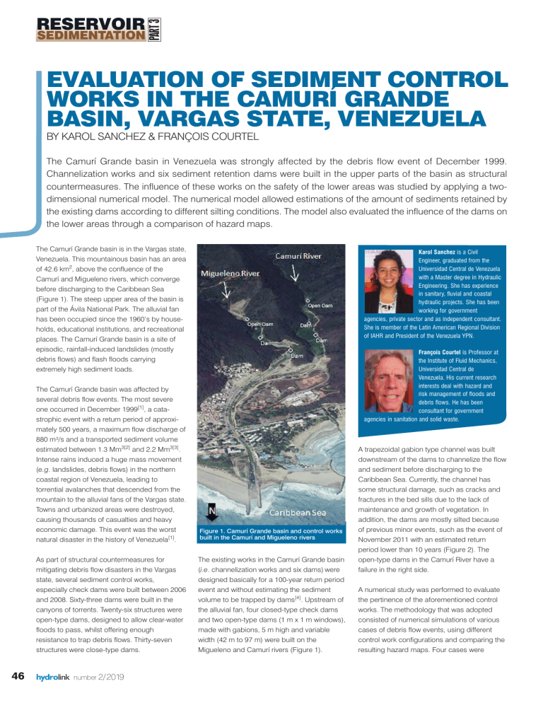
SEDIMENTATION PART 3 RESERVOIR EVALUATION OF SEDIMENT CONTROL WORKS IN THE CAMURÍ GRANDE BASIN, VARGAS STATE, VENEZUELA BY KAROL SANCHEZ & FRANÇOIS COURTEL The Camurí Grande basin in Venezuela was strongly affected by the debris flow event of December 1999. Channelization works and six sediment retention dams were built in the upper parts of the basin as structural countermeasures. The influence of these works on the safety of the lower areas was studied by applying a twodimensional numerical model. The numerical model allowed estimations of the amount of sediments retained by the existing dams according to different silting conditions. The model also evaluated the influence of the dams on the lower areas through a comparison of hazard maps. The Camurí Grande basin is in the Vargas state, Venezuela. This mountainous basin has an area of 42.6 km2, above the confluence of the Camurí and Migueleno rivers, which converge before discharging to the Caribbean Sea (Figure 1). The steep upper area of the basin is part of the Ávila National Park. The alluvial fan has been occupied since the 1960’s by households, educational institutions, and recreational places. The Camurí Grande basin is a site of episodic, rainfall-induced landslides (mostly debris flows) and flash floods carrying extremely high sediment loads. The Camurí Grande basin was affected by several debris flow events. The most severe one occurred in December 1999[1], a catastrophic event with a return period of approximately 500 years, a maximum flow discharge of 880 m³/s and a transported sediment volume estimated between 1.3 Mm3[2] and 2.2 Mm3[3]. Intense rains induced a huge mass movement (e.g. landslides, debris flows) in the northern coastal region of Venezuela, leading to torrential avalanches that descended from the mountain to the alluvial fans of the Vargas state. Towns and urbanized areas were destroyed, causing thousands of casualties and heavy economic damage. This event was the worst natural disaster in the history of Venezuela[1]. As part of structural countermeasures for mitigating debris flow disasters in the Vargas state, several sediment control works, especially check dams were built between 2006 and 2008. Sixty-three dams were built in the canyons of torrents. Twenty-six structures were open-type dams, designed to allow clear-water floods to pass, whilst offering enough resistance to trap debris flows. Thirty-seven structures were close-type dams. 46 hydrolink number 2/2019 Karol Sanchez is a Civil Engineer, graduated from the Universidad Central de Venezuela with a Master degree in Hydraulic Engineering. She has experience in sanitary, fluvial and coastal hydraulic projects. She has been working for government agencies, private sector and as independent consultant. She is member of the Latin American Regional Division of IAHR and President of the Venezuela YPN. François Courtel is Professor at the Institute of Fluid Mechanics, Universidad Central de Venezuela. His current research interests deal with hazard and risk management of floods and debris flows. He has been consultant for government agencies in sanitation and solid waste. Figure 1. Camurí Grande basin and control works built in the Camurí and Migueleno rivers The existing works in the Camurí Grande basin (i.e. channelization works and six dams) were designed basically for a 100-year return period event and without estimating the sediment volume to be trapped by dams[4]. Upstream of the alluvial fan, four closed-type check dams and two open-type dams (1 m x 1 m windows), made with gabions, 5 m high and variable width (42 m to 97 m) were built on the Migueleno and Camurí rivers (Figure 1). A trapezoidal gabion type channel was built downstream of the dams to channelize the flow and sediment before discharging to the Caribbean Sea. Currently, the channel has some structural damage, such as cracks and fractures in the bed sills due to the lack of maintenance and growth of vegetation. In addition, the dams are mostly silted because of previous minor events, such as the event of November 2011 with an estimated return period lower than 10 years (Figure 2). The open-type dams in the Camurí River have a failure in the right side. A numerical study was performed to evaluate the pertinence of the aforementioned control works. The methodology that was adopted consisted of numerical simulations of various cases of debris flow events, using different control work configurations and comparing the resulting hazard maps. Four cases were SEDIMENTATION IAHR PART 3 RESERVOIR Figure 2. Open dam built in the Camurí River. Downstream views in 2008 (left) and 2011 (right)[9] simulated: without control works (Case 1), with channelization works only (Case 2), with channelization works and empty dams (Case 3), and with channelization works and dams filled up with sediments at the equilibrium slope[5] (Case 4 - considered as the current one). According to the analysis of recorded previous bed profiles[6], the actual bed slope upstream of the dams was deemed as being at equilibrium. The events generated by rainfall of 10, 100 and 500 year return periods were analyzed with 24 hours duration storms[3] using the numerical model RiverFlow2DPlus[7]. Numerical modeling approach: Data and methodology RiverFlow2DPlus is a two-dimensional hydrodynamic model, with a finite-volume scheme Table 1. Volume of retained sediments Case 3 Case 4 Return period event Total sediment volume (m3) Retained volume (m3) Retained percentage (%) Retained volume (m3) Retained percentage (%) 500-years 2,370,896 416,790 17.6 230,748 9.7 100-years 1,467,711 341,540 23.3 171,340 11.7 10-years 406,296 159,345 39.2 70,434 17.3 Figure 3. Results for Case 3- Sedimentation upstream of the dams due to a 100-year return period debris flow. The time evolution of the longitudinal bed profile is also shown. The flow pic discharge occurred at hour 5 Figure 4. Results for Case 4- Sedimentation upstream of the dams due to a 100-year return period debris flow. The time evolution of the longitudinal bed profile is also shown and flexible-mesh[7]. The public domain geographic information system platform QGIS was used as a graphical interface. RiverFlow2DPlus includes a conventional sediment transport module (bed load and suspended load) (ST), and a non-Newtonian hyper concentrated flow module (Mud and Debris Flows) (MD). The ST module simulates sediment deposition and erosion but requires much greater computational capacity than the MD module. The MD module considers the water-sediment mixture as monophasic, reproduces its rheological characteristics while ignoring the sedimentation process. The flow volumetric concentration in the Camurí Grande is between conventional flows and fully developed debris flow (from 10% to 30%). The ST and MD modules were employed separately, namely (i) the MD model was applied to the lower area of the basin (cases 1, 2, 3 and 4), and (ii) the ST was applied upstream of dams (cases 3 and 4). The February 7-10th 2005 event was simulated to calibrate the numerical model (e.g. for cell size and roughness) using the observed flow and sediment deposit depths. During this event, the rainfall was continuously recorded at the Naiguatá station located within the Camurí river basin; the flow hydrograph (i.e. runoff) was estimated using the numerical model HEC-HMS[8]. Simulating the 2005 event, the numerical results agreed closely with the field data, in terms of maximum flow depths and deposited sediment depths. Results The ST module was used to predict sediment deposition upstream of the dams (Case 3, i.e. channelization works and initial empty dams). A simplification in the sediment size range was applied, considering only the sand fraction. hydrolink number 2/2019 47 IAHR The transport of boulders cannot be simulated by the ST model. The Meyer-Peter and Müller[7] formula computed the sediment discharge. Figure 3 shows the final bed sedimentation profile upstream of the dams in the Case 3. It was found that the six existing dams can retain almost 18%, 23% and 39% of the total sediment volume associated with 500-, 100and 10-year return period events, respectively (Table 1). Figure 4 displays the results for Case 4 (i.e. channelization works and dams filled up with sediments), showing sediment deposition upstream of the dams, although the river bed was considered to be in equilibrium. This process, which occurs during exceptional floods[6], allows a temporally additional, appreciable sediment retention capacity, as in Case 4 dams retain around 50% of the sediment volume retained by the empty dams in Case 3. In Case 4 the six existing dams can retain almost 10%, 12% and 17% of the total sediment volume associated with 500-, 100- and 10-year return period events, respectively (Table 1). In the urban area, where hazard maps are required[10], the MD module was applied, due to its more physically realistic description of debris flows and its low computational costs. The MD module used the quadratic rheological formulation, which includes inertial and viscous terms[11]. The criteria for the development of hazard maps were based on maximum flow depth and velocity, following the Venezuelan regulations[10,12]. The following hazard levels were considered: • Red (High hazard level): people inside and outside of buildings are in danger. There is a high risk of buildings being destroyed. The marked area corresponds essentially to be a prohibited zone. • Orange (Medium hazard level): people outside of buildings are in danger, but are safe when inside. Houses and buildings can be damaged but not destroyed. The orange zone is essentially a regulatory zone. • Yellow (Low hazard level): the danger for people is low or nonexistent. Buildings may suffer minor damage. The yellow zone is essentially an area where the only action to be taken is to raise awareness about the potential of debris flows. The influence of the control works against debris flow was evaluated in each case, Figure 5. Hazard maps for Cases 1, 2, 3 and 4 comparing the hazard maps and considering the three hazard levels (Figure 5). All comparisons were made in relation to Case 1 (i.e. without control works). A relevant result is that in Case 2 the total hazard area (i.e. red, orange and yellow areas) decreased by 22% and the red hazard area decreased by 48%. In Case 3 the total area decreased by 25% and the red hazard area decreased by 66%. In Case 4 the total and high hazard areas were very similar to those in Case 3, demonstrating that dams in their equilibrium conditions can also contribute to reduce the hazard. However, periodic extractions of sediments are recommended. Conclusion and recommendations The present study provides insights into risk management in the Camurí Grande basin. The existing structures play an important role in decreasing the consequences of debris flows on the lower parts of the basin. According to the hazard map, the reduction of the high hazard level is of the order of 66%. It must be noted that the Venezuelan hazard map criteria[10,12] include the 500-year event, greater than the 100-year event which was used to design the control works. The residual hazard should be dealt by non-structural measures, such as land use restrictions, Early Warning System (EWS), emergency plans and education of the local population about the potential hazards. To improve the structural countermeasures for debris flow disasters in the Camurí Grande basin, it is recommended to develop an accurate estimation of the available sediments in the basin (riverbeds and hillsides), to improve the channel capacity and to build new check dams for trapping boulders and larger size sediments, following the scheme of a series of open-type and closed-type dams implemented in other basins in the Vargas state. n References [1] López, J.L., Courtel, F. (2016). The 1999 Debris flows disaster in Venezuela: What has been done for risk mitigation purposes? Hydrolink, 3, 79-80. [2] Ishikawa, Y. (2001). Flood-deposition characteristics of debris flows and runoff sediment volume on coastal alluvial fans (Debris flow disasters in the Province of Vargas, Republic of Venezuela in 1999). Journal of the Japan Society of Erosion Control Engineering, 53(4), 23-33. [3] C.G.R. INGENIERÍA (2000). Estudio crecidas cuencas Litoral Central, DF. AUAEV – MTC. Vargas, Venezuela. [4] M.G.R. CONSULTORES. (2002). Proyecto de control de sedimentos río Camurí Grande, estado Vargas. Presa río Camurí No 1-2. Presa río Migueleno No 1-2. Corporación para la Recuperación y Desarrollo del Estado Vargas, Venezuela. [5] Takahashi, T. (2014). Debris Flow. Mechanics, Prediction and Countermeasures. London, UK. 528 p. [6] Suarez, L. (1993). Presas de Corrección de Torrentes y Retención de Sedimentos. Ministerio del Ambiente y de los Recursos Naturales. Caracas, Venezuela. [7] Hydronia (2015). Two-Dimensional Finite-Volume River Dynamics Model. Argus ONE edition- Release v5 User s Guide. Florida, United States. [8] US Army Corps of Engineers. (2016). Hydrologic Modeling System HEC-HMS. Quick Start Guide Version 4.2. Hydrologic Engineering Center. California, United States. [9] López, J.L., Courtel, F. (2011). Situación actual de las obras de mitigación de riesgos hidrometeorológicos en la cuenca del río Camurí. Informe técnico: Vargas, Venezuela. [10] IMF. (2002). Mapas de amenaza por aludes torrenciales en las zonas del estado Vargas y del valle de Caracas definidas en el Proyecto Ávila. Informe Final. Centro de Estudios de Desastres Ambientales -Instituto de Mecánica de Fluidos - Facultad de Ingeniería - Universidad Central de Venezuela, Caracas, Venezuela. [11] O Brien, J., Julien, P. (1988). Laboratory Analysis of Mudflow Properties. Journal of Hydraulic Engineering, 114(8), 877-887. [12] López J.L., Courtel F. (2010). Medidas y acciones para un sistema integral de control de inundaciones y aludes torrenciales y su aplicación en Vargas, Venezuela”. IAHR XXIV International Congress, Punta del Este, Uruguay. Acknowledgements The authors would like to express their special thanks to the Institute of Fluids Mechanics, Engineering Faculty, Universidad Central de Venezuela for their support throughout the study and to the Professor Reinaldo García for facilitating the RiverFlow2DPlus model. hydrolink number 2/2019 49


