PRG SR y SIG 2009
Anuncio

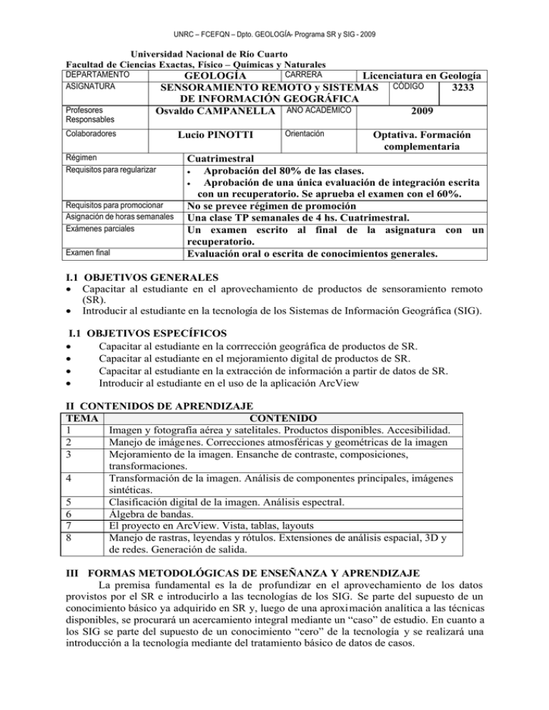
UNRC – FCEFQN – Dpto. GEOLOGÍA- Programa SR y SIG - 2009 Universidad Nacional de Río Cuarto Facultad de Ciencias Exactas, Físico – Químicas y Naturales DEPARTAMENTO ASIGNATURA Profesores Responsables CARRERA GEOLOGÍA Licenciatura en Geología 3233 SENSORAMIENTO REMOTO y SISTEMAS CÓDIGO DE INFORMACIÓN GEOGRÁFICA Osvaldo CAMPANELLA AÑO ACADÉMICO 2009 Colaboradores Régimen Requisitos para regularizar Requisitos para promocionar Asignación de horas semanales Exámenes parciales Examen final Lucio PINOTTI Orientación Optativa. Formación complementaria Cuatrimestral • Aprobación del 80% de las clases. • Aprobación de una única evaluación de integración escrita con un recuperatorio. Se aprueba el examen con el 60%. No se prevee régimen de promoción Una clase TP semanales de 4 hs. Cuatrimestral. Un examen escrito al final de la asignatura con un recuperatorio. Evaluación oral o escrita de conocimientos generales. I.1 OBJETIVOS GENERALES • Capacitar al estudiante en el aprovechamiento de productos de sensoramiento remoto (SR). • Introducir al estudiante en la tecnología de los Sistemas de Información Geográfica (SIG). I.1 OBJETIVOS ESPECÍFICOS • Capacitar al estudiante en la corrrección geográfica de productos de SR. • Capacitar al estudiante en el mejoramiento digital de productos de SR. • Capacitar al estudiante en la extracción de información a partir de datos de SR. • Introducir al estudiante en el uso de la aplicación ArcView II CONTENIDOS DE APRENDIZAJE TEMA CONTENIDO 1 Imagen y fotografía aérea y satelitales. Productos disponibles. Accesibilidad. 2 Manejo de imágenes. Correcciones atmosféricas y geométricas de la imagen 3 Mejoramiento de la imagen. Ensanche de contraste, composiciones, transformaciones. 4 Transformación de la imagen. Análisis de componentes principales, imágenes sintéticas. 5 Clasificación digital de la imagen. Análisis espectral. 6 Álgebra de bandas. 7 El proyecto en ArcView. Vista, tablas, layouts 8 Manejo de rastras, leyendas y rótulos. Extensiones de análisis espacial, 3D y de redes. Generación de salida. III FORMAS METODOLÓGICAS DE ENSEÑANZA Y APRENDIZAJE La premisa fundamental es la de profundizar en el aprovechamiento de los datos provistos por el SR e introducirlo a las tecnologías de los SIG. Se parte del supuesto de un conocimiento básico ya adquirido en SR y, luego de una aproximación analítica a las técnicas disponibles, se procurará un acercamiento integral mediante un “caso” de estudio. En cuanto a los SIG se parte del supuesto de un conocimiento “cero” de la tecnología y se realizará una introducción a la tecnología mediante del tratamiento básico de datos de casos. UNRC – FCEFQN – Dpto. GEOLOGÍA- Programa SR y SIG - 2009 IV GUIA DE ACTIVIDADES Se actualiza en el desarrollo del proceso de enseñanza aprendizaje en función de los conocimientos y potencialidades de los estudiantes. VI BIBLIOGRAFÍA La presente lista es sólo de los principales libros y publicaciones. En la guía de actividades se entrega una lista más detallada de la bibliografía disponible. Se entregan, además, bibliografía en soporte digital. Aronoff, S. 1995. Geographic Information Systems: A Management Perspective. WDL Publications, Ottawa, Canadá. Brodie, R.S. 1998. Integrating Gis and Rdbms Technologies During Construction of a Regional Groundwater Model. Environmental Modelling and Software, 14(2-3): 119128. Canada Centre for Remote Sensing. 2008. Tutorial: Fundamentals of Remote Sensing. http://www.ccrs.nrcan.gc.ca/resource/tutor/fundam/index_e.php Chen, P. 1977. The Entity-Relationship Approach to Logical Data Base Design. In The Q.E.D. Monograph Series: Data Management. Edited by M. Wellesley, Vol.1, pp. 9 36. Chuvieco, E. 2002. Teledetección Ambiental. Editorial Ariel, Barcelona. Dai, F.C., Lee, C.F., and Zhang, X.H. 2001. Gis-Based Geo-Environmental Evaluation for Urban Land_Use Planning: A Case Study. Engineering Geology, 61: 257-271. Dengsheng Lua, Q.W. 2006. Use of Impervious Surface in Urban Land-Use Classification. Remote Sensing and Environment, 102(1 2): 146 160. Densham, F.C., Lee, C.F., and Zhang, X.H. 2001. Gis-Based Geo-Environmental Evaluation for Urban Land-Use Planning: A Case Study. Engineering Geology, 61: 257–271. Diamond, J.T., and Wright, J.R. 1988. Design of an Integrated Spatial Information System for Multiobjective Land Use Planning. Environment and Planning, B 15(12): 205-214. Esri 1998. Arcview Gis. The Geographic Information System for Everyone. Esri 1999. Arcview Gis 3.2. Environmental Systems Research Institute, Inc. Gómez-Rubio, V., and López-Quílez, A. 2005. Rarcinfo: Using Gis Data with R. Computers & Geosciences, 31: 1000 - 1006. Goodchild, M.F. 1993. The State of Gis for Environmetal Problem Solving. In Environmental Modelling with Gis. Oxford University Press, New York. pp. 8-15. Jiang, H., and Eastman, J.R. 2000. Aplication of Fuzzy Measures in Multi-Criteria Evaluation in Gis. Internacional Journal of Geographical Information Systems, 14(2): 173-184. Keller, C.P. 1996. Decision Making Using Multiple Criteria. Lacan, I., Zhou, J.Y., Liu, K.-S., and Waldman, J. 2006. A Geographic Information Systems (Gis) and Spatial Modeling Approach to Assessing Indoor Radon Potential at Local Level. Applied Radiation and Isotopes, 64: 490 - 496. Lembo, A.J.J., Young Lew, M., Laba, M., and Baveye, P. 2006. Use of Spatial Sql to Assess the Practical Significance of the Modifiable Areal Unit Problem. Computers & Geosciences, 32(2): 270-274. Lillesand, T.M., and Kiefer, R.W. 2000. Remote Sensing and Image Interpretation. John Wiley & Son, Nueva York. Malczewski, J. 1999. Gis and Multicriteria Decision Analysis. John Willey and Sons Inc. Martin, D., Longley, P., and Higgs, G. 1994. The Use of Gis in the Analysis of Diverse Urban Databases. Computers, Environment and Urban Systems, 18(1): 55-66. Mcconnell, L.M., Van Vliet, D., and Cook, T.J. 2006. A New Suite of User-Friendly Gis Tools for Accessing Environmental Monitoring Databases. In 2006 ESRI User Conference. Edited by ESRI. UNRC – FCEFQN – Dpto. GEOLOGÍA- Programa SR y SIG - 2009 Mundia, C.N., and Aniya, M. 2005. Analysis of Land Use/Cover Changes and Urban Expansion of Nairobi City Using Remote Sensing and Gis. International-Journal-ofRemote-Sensing, 26 (13): 2831-2849. NASA. 2008. The Remote Sensing Tutorial. http://rst.gsfc.nasa.gov/ Passmore, J. 1997. Construction of a Dynamic Gis Tool Kit for the Visualization, Analysis and Prediction of Bankline Movement Along the Jamuna River, Bangladesh, The University of Nottingham, Nottingham. Reitner, H., and Lipiarski, P. 1994. Wellmaster - Processing of Borehole-Data with Arcinfo and Arcview. In 13º European ESRI User Conference. Edited by ESRI. Firenze, Italy. ESRI. Tait, N.G., Davison, R.M., Whittaker, J.J., Leharne, S.A., and Lerner, D.N. 2004. Borehole Optimisation System (Bos) a Gis Based Risk Analysis Tool for Optimising the Use of Urban Groundwater. Environmental Modelling & Software, 19: 1111 1124. Thome, K., Palluconi, F., Takashima, T., and Masuda, K. 1998. Atmospheric Correction of Aster. IEEE Transactions of Geoscience and Remote Sensing, 36(4): 1199 - 1211.

