Extended Abstract
Anuncio
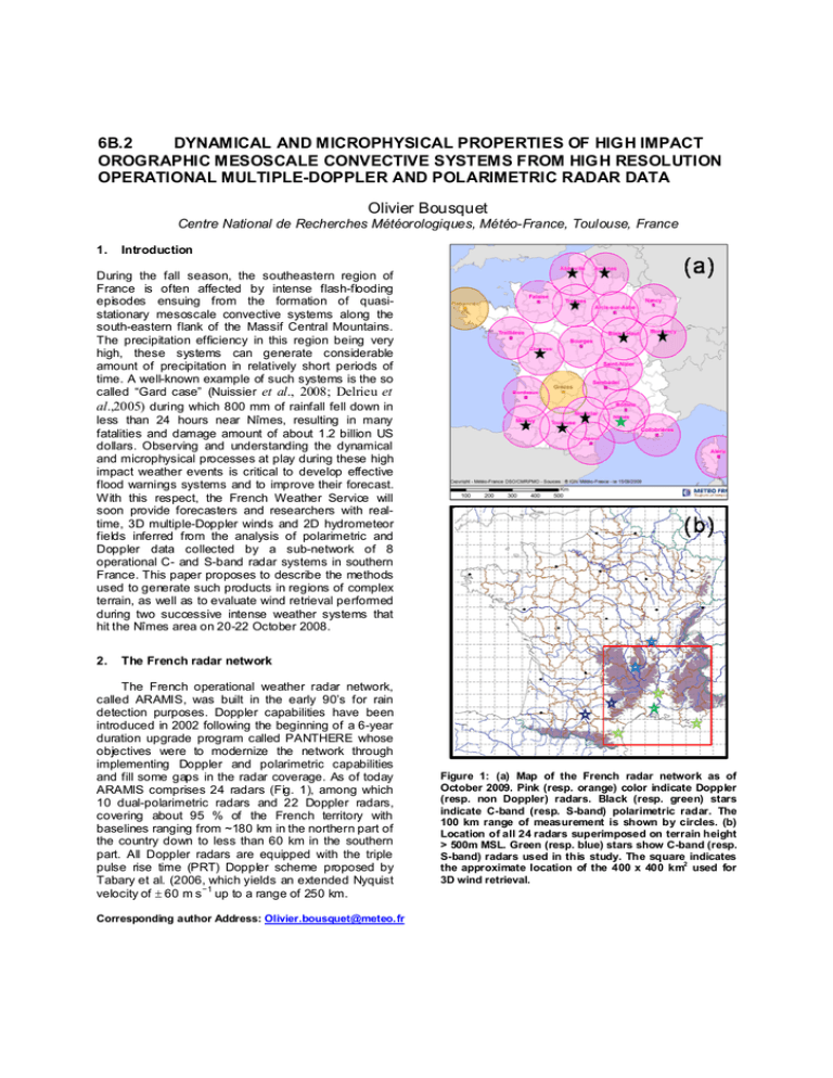
6B.2 DYNAMICAL AND MICROPHYSICAL PROPERTIES OF HIGH IMPACT OROGRAPHIC MESOSCALE CONVECTIVE SYSTEMS FROM HIGH RESOLUTION OPERATIONAL MULTIPLE-DOPPLER AND POLARIMETRIC RADAR DATA Olivier Bousquet Centre National de Recherches Météorologiques, Météo-France, Toulouse, France 1. Introduction During the fall season, the southeastern region of France is often affected by intense flash-flooding episodes ensuing from the formation of quasistationary mesoscale convective systems along the south-eastern flank of the Massif Central Mountains. The precipitation efficiency in this region being very high, these systems can generate considerable amount of precipitation in relatively short periods of time. A well-known example of such systems is the so called “Gard case” (Nuissier et al., 2008; Delrieu et al.,2005) during which 800 mm of rainfall fell down in less than 24 hours near Nîmes, resulting in many fatalities and damage amount of about 1.2 billion US dollars. Observing and understanding the dynamical and microphysical processes at play during these high impact weather events is critical to develop effective flood warnings systems and to improve their forecast. With this respect, the French Weather Service will soon provide forecasters and researchers with realtime, 3D multiple-Doppler winds and 2D hydrometeor fields inferred from the analysis of polarimetric and Doppler data collected by a sub-network of 8 operational C- and S-band radar systems in southern France. This paper proposes to describe the methods used to generate such products in regions of complex terrain, as well as to evaluate wind retrieval performed during two successive intense weather systems that hit the Nîmes area on 20-22 October 2008. 2. The French radar network The French operational weather radar network, called ARAMIS, was built in the early 90’s for rain detection purposes. Doppler capabilities have been introduced in 2002 following the beginning of a 6-year duration upgrade program called PANTHERE whose objectives were to modernize the network through implementing Doppler and polarimetric capabilities and fill some gaps in the radar coverage. As of today ARAMIS comprises 24 radars (Fig. 1), among which 10 dual-polarimetric radars and 22 Doppler radars, covering about 95 % of the French territory with baselines ranging from ~180 km in the northern part of the country down to less than 60 km in the southern part. All Doppler radars are equipped with the triple pulse rise time (PRT) Doppler scheme proposed by Tabary et al. (2006, which yields an extended Nyquist velocity of ± 60 m s −1 up to a range of 250 km. Corresponding author Address: Olivier.bousquet@meteo.fr Figure 1: (a) Map of the French radar network as of October 2009. Pink (resp. orange) color indicate Doppler (resp. non Doppler) radars. Black (resp. green) stars indicate C-band (resp. S-band) polarimetric radar. The 100 km range of measurement is shown by circles. (b) Location of all 24 radars superimposed on terrain height > 500m MSL. Green (resp. blue) stars show C-band (resp. S-band) radars used in this study. The square indicates the approximate location of the 400 x 400 km2 used for 3D wind retrieval. Figure 2: (a) detailed topography within the 400 x 400 km2 used for 3D wind retrieval. Radar locations are indicated by stars. The black square indicates the approximate location of the 200 x 200 km2 domain used for higher resolution retrieval. (b)(c): Effective dual- (blue) and multiple- (brown) Doppler radar overlapping at 1 km (b) and 3 km (c) MSL. 3. Experimental setup Multiple-Doppler analysis are performed within a Cartesian domain measuring 400 km x 400 km x 12 km centered near Nimes S-band polarimetric Doppler radar (Fig. 2) that is also covered by 3 other S-band radar and 4 C-band radars (Fig. 1). The vertical resolution of the domain of analysis is set to 500 m, while the horizontal resolution is set to 2.0 km. The corresponding dual- and multiple-Doppler coverage maps at 1 km and 3 km MSL are shown in fig. 2 (note that the radar overlapping shown in Fig. 2 represents the effective dual- and multiple-Doppler coverage as it both takes into account beam blocking by the terrain and excludes badly defined region in dual-Doppler covered area). A second domain with a horizontal resolution of 1 km and a size of 200 x 200 km² is also used for wind retrieval at higher horizontal resolution (Fig. 2a). All radars perform a complete volume scan in 15 minutes, but scanning strategies are radar specific. For more details about volume coverage patterns and scanning strategy please refer to Kergomard et al. (2009). Data consist in operational Plan Position Indicators (PPI) of Doppler velocity and reflectivity projected on a 1 km 2 Cartesian grid, which are synchronized with respect to the ending time of the current 15’ period to account for the non-simultaneity of the measurements. Spurious reflectivity and radial velocity data are removed using a threshold on the pulse-to-pulse fluctuation of the reflectivity and a 5x5 km² median filter, respectively. Once pre-processed, data are then interpolated into the Cartesian grid using a fixed horizontal influence radius of the Cressman weighting function RH of 3 km and a variable vertical radius of influence RV equal to 1° (beamwidth of the ARAMIS radars). In this configuration, R V varies as a function of range so that the search for data points extends farther out at long range compared to short range. At long range, this also allows to indirectly take into account the lost of resolution resulting from beam broadening. Once interpolated, data are ingested in the MUSCAT (Multiple-Doppler Synthesis and Continuity Adjustment Technique) algorithm, as originally proposed by Bousquet and Chong (1998) and recently modified by Bousquet et al. (2008) to allow for the analysis of operational radar data. Finally, because the three-dimensional wind field reconstructed using MUSCAT represents a leastsquares fit to the available observations, and hence does not perfectly satisfy the mass continuity equation, an a posteriori integration is performed following the variational method of Georgis et al. (2000) subject to simultaneous minimization of both (1) the horizontal gradient of vertical velocity within the domain of interest and (2) vertical velocity at the upper boundary. The reader may refer to this paper for further details. In addition to wind retrieval, we have also started to analyze polarimetric data collected from Nimes Sband polarimetric radar to achieve hydrometeor classification following an approach similar to that proposed by Park et al. (2009). Microphysical retrieval will however not be shown in this paper as polarimetric data have not been archived until the beginning of 2009. 4. The 20-22 October 2008 MCS A qualitative evaluation of the multiple-Doppler winds reconstructed in this framework is provided through the analysis of radar data collected during two heavy rain events observed in late October 2008. The first event consists in an isolated MCS (Fig. 3) that developed along the south-eastern flank of the Massif Central Mountains on October 20th and remained stationary for about 15 hours. Although this storm did not generate any significant damage, it locally produced rainfall accumulation in excess of 250 mm in a just a few hours. The retrieved wind field at 14 UTC shows a rather complex wind circulation resulting from the interactions between the incident flow and the terrain. A region of strong convergence was observed near Nimes due to the interactions of W’ly flow in the southern part of the massif with S’ly- to-SW’ly flow to the east. As a consequence, strong convection could be observed in this region while more stratiform precipitation, associated with older cells, could be seen to the North. The vertical velocity field in the convective region also shows intense updraft up to 8 m/s, which is consistent with observed reflectivity cores up to 60 dBZ. Figure 3: Stationary mesoscale convective system observed on 20 October 2008 at 14 UTC. (Left, top): French operational radar reflectivity mosaic output. (Right): Horizontal wind vectors superimposed on radar reflectivity (shaded) at 2.5 km MSL within the 200 km x 200 km experimental domain shown in Fig. 2, as derived from multiple-Doppler analysis of radar data. (Left, bottom): Associated retrieved vertical velocity. Triangles show the location of Nimes and Bollène radars. Figure 4: French operational radar reflectivity mosaic outputs on 21 October 2008 at 00, 12, and 23 UTC Figure 5: Horizontal wind vectors superimposed on radar reflectivity (shaded) at 0.5 km (left panel) and 2.0 km (right panel) MSL within the 200 km x 200 km experimental domain shown in Fig. 2, as derived from multiple-Doppler analysis of radar data at (a) 00:00 UTC, (top) 04:00 UTC (middle), and 08:00 UTC (bottom) on 22 November 2008. One every sixth vector is plotted. The day after, a new stationary MCS formed at about the same location (Fig. 4). This time, however, the situation was slightly more complex as a rain band associated with a southeastward propagating cold front merged with the isolated MCS at the end of the day and eventually swept away the MCS. Figure 5 shows the evolution of the MCS between 0 UTC and 8 UTC on the 22 nd of October. The retrieved wind fields clearly show the wind shift associated with the cold front. Also note how the strong low-level southerly flow impinging on the barrier at 0 UTC quickly weakened as the front approached the eastern flank of the Massif. 5. Conclusions This study suggests that reliable Multiple Doppler wind fields can now be produced routinely from operational Doppler radar systems operated in region of complex terrain. Although more work is needed to validate the winds retrieved in this framework, the development presented in this paper is expected to provide valuable data to better understand the physical processes associated with orographic precipitation. These wind data, together with microphysical information derived from the analysis of polarimetric parameters, will also be particularly suitable to evaluate mesoscale dynamical and microphysical features produced by high resolution NW P systems. References Bousquet O., and M. Chong, 1998: A multiple Doppler and continuity adjustment technique (MUSCAT) to recover wind components from Doppler radar measurements. J. Atmos. Oceanic Technol., 15, 343-359. Bousquet, O., P. Tabary, and J. Parent du Chatelet, 2008: Operational multiple-Doppler wind retrieval inferred from long range radar velocity measurements, J. Appl. Meteorol. Clim., 47, 2929–2945. Delrieu G and coauthors, 2005: The catastrophic flash-flood event of 8–9 September 2002 in the Gard region, France: A first case-study for the Mediterranean Hydrometeorological Observatory. J. Hydrometeorol. 6: 34–52. Georgis, J.-F., F. Roux, and P.H. Hildebrand, 2000: Observation of precipitating systems over complex orography with meteorological Doppler radars: A feasibility study. Meteor. Atmos. Phys., 72, 185-202. Kergomard, A., P. Dupuy, O. Bousquet and P. Tabary, 2009: Real-time, nationwide production of 3D wind and reflectivity fields in France: science, engineering and applications. This AMS conference. Nuissier O, Ducrocq V, Ricard D, Lebeaupin C, Anquetin S., 2008: A numerical study of three catastrophic precipitating events over Southern France. I: Numerical framework and synoptic ingredients. Q. J. R. Meteorol. Soc. 134: 111–130 Park, H., A. V. Ryzhkov, D. S. Zrnic', and Kyung-Eak Kim, 2009: The Hydrometeor Classification Algorithm for the Polarimetric WSR-88D: Description and Application to an MCS. Wea. Forecasting, 24, 730–748. Tabary, P., F. Guibert, L. Perier, and J. Parent-du-chatelet, 2006: An operational triple-PRT scheme for the French radar network. J. Atmos. Oceanic Technol.,23, 1645-1656.

