Technology SAR-Lupe Satellites launched
Anuncio
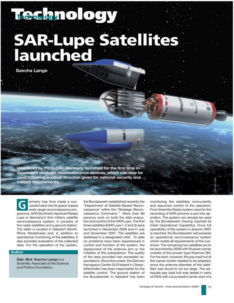
Technology Technology SAR-Lupe Satellites launched Sascha Lange G ermany has thus made a successful start into its space-based wide range reconnaissance programme. SAR (Synthetic Aperture Radar) Lupe is Germany’s first military satellite reconnaissance system. It consists of five radar satellites and a ground station. The latter is located in Gelsdorf (NorthRhine Westphalia) and, in addition to operational monitoring of the satellites; it also provides evaluation of the collected data. For the operation of the system, Author Dipl.-Biol. Sascha Lange is a Scientific Associate of the Science and Politics Foundation. the Bundeswehr established recently the “Department of Satellite-Based Reconnaissance” within the “Strategic Reconnaissance Command “. More than 90 persons work on both the data evaluation and control of the SAR Lupe. The first three satellites (SAR Lupe 1, 2 and 3) were launched in December 2006 and in July and November 2007. The satellites are stabilised in a designated orbit. To date no problems have been experienced in control and function of the system, the deployment of the antenna arm or the initiation of the subsystems. The quality of the data provided has exceeded expectations. Since the outset, the German Aerospace Centre DLR based in Oberpfaffenhofen has been responsible for the satellite control. The ground station of the Bundeswehr in Gelsdorf has been (Photos: OHB) Unnoticed by the public, Germany launched for the first time independent strategic reconnaissance devices, which can now be used following political direction given for national security and military requirements. monitoring the satellites concurrently and assumed control of the operation. From there the Radar system used for the recording of SAR pictures is put into operation. The system can already be used by the Bundeswehr (having reached its Initial Operational Capability). Once full operability of the system in autumn 2007 is reached, the Bundeswehr will possess an operational reconnaissance system which meets all requirements of the customer. The remaining two satellites are to be launched by 2008 with Russian carrier rockets of the proven type Kosmos-3M. For the start, however, the pay load hull of the carrier rocket needed to be adapted, since the antenna diameter of the satellites was found to be too large. The adequate pay load hull was tested in early of 2005 with a successful carrier start of a Strategie & Technik – International Edition II/2007 13 Technology Russian satellite. The employed booster rocket claims a success record of over 97 per cent of starts in the past. If all starts are successful and the satellites perform their functions, full operational capability will be achieved in the year 2008. The system concept foresees the five satellites being stationed in three different orbits above the poles, at a height of 500 km. Two orbits are each covered with two satellites. The other orbit is covered with just one satellite. This segmentation guarantees that the average delay from a request to the provision of evaluated pictures amounts to only 11 hours. Almost all requests for reconnaissance can be responded to within 24 hours. Satellite Technics The weight of a SAR Lupe satellite amounts to almost 720 kg. The dimensions are: 3 m width x 4 m height x 2 m depth. The satellite’s radar antenna is 3 meters. Satellite availability of more than 97 per cent is required over the designated life span of at least 10 years. The average energy consumption is around 250 Watts. The satellite does not preprocess the raw data, but passes them on to the ground station. X-band is used for data transmission from the satellite to the ground station. Connectivity to the ground station is only achieved when the satellite is exactly above the Preparing the rocket for the start station. Control and status data of the satellite are encoded and exchanged over the S-band link. Additionally, these data can also be passed on over the inter-satellite link, in order to transmit requests for reconnaissance even if the satellite is “out of view” of the ground station. Each satellite is equipped with a memory of more than 128 GB. This design feature should allow the system to provide more than 25 pictures per day. Only limitations in power supply and data communication prevent an even higher number of photographs being provided. The satellite is spatially stabilised by solenoid coil driven flywheels. The orbit is positioned by means of hydrazine engines if necessary. Since the solar cells on the back of the satellite are not pivoting, the satellite adapts the already generated electrical output through its alignment to the sun. Radar technology The use of radar technology has different advantages related to the mostly optical systems of the so-called imaging reconnaissance systems. Radar beam images can also be acquired at night and in adverse weather conditions, since they penetrate darkness and clouds effectively. Furthermore, distances (e.g. differences in altitude) can be measured very accurately. Since radar waves are particularly well reflected by metal surfaces, technical objects (e.g. vehicles and large installations) can be detected easily, even partially through vegetation. Thus, Germany, as only the third nation after the United States of America and Russia, is able to acquire high resolution photographs of the globe, with the help of radar technology, that are uninfluenced by the weather or the time of day. The name “Lupe” (Magnifying glass) refers to the ability, to examine particularly important targets with significantly higher resolution. For this the satellites use a special so-called Synthetic Aperture Radar (Radar with an artificially computed large antenna). This SAR technology makes it possible to increase the resolution of the images by recording a series of images of the target from different angles and in Integration of the antenna 14 Strategie & Technik – International Edition II/2007 Technology short intervals. The reconnaissance result is remarkable and significantly better than with Radarsat 2 or COSMO Skymed. This is achieved through the appropriate data being substantially re-processed with the SAR Lupe computers. Photograph formats (Diagram: Bocklet) The most important photograph format is the so-called Strip Map Mode for the large area of targets with strip dimensions of 60x8 km. Under the so-called Spot Light Mode the satellite pivots to an extent so that the orbit movement can be aligned to the surface, thus achieving a higher resolution. The edge length of these strips, however, is reduced to 5,5 x 5,5 km. The width of these photographs is not only limited by radar technology but also by the internal data processing and the current power supply on board the satellite. Under the magnifying glass mode resolutions of less than 80 cm can be achieved. According to claims by the manufacturer, this resolution is even greater than those of substantially more expensive American and Russian radar satellites. With successful development, this system will be capable of delivering Erecting the 109-tons-rocket time the costs rose to over five billion DM. The serious requirement for the development and operation of a German reconnaissance satellite system was gener- SAR-Lupe-summary Number of satellites: 5, identical construction Middle orbit height: Approx. 500 km, optimised for high resolution Orbit inclination: polar, all of them Number of orbit levels: 3 Size: approx. 4 m x 3 m x 2 m Weight: approx. 720 kg Service life: 10 years Customer: Federal Ministry of Defence Federal Office for Defence Technology and Procurement Mission: Generating high resolution SAR (Synthetic Aperture Radar) images for military reconnaissance purposes the most militarily important over flight per time rate (revisit rate) that will exceed those generated by the radar satellite systems of the old great space powers. History and Future In consideration of the promising performance data and its very low internationally comparable cost, the SAR Lupe system must be considered an exceptionally good deal, especially when compared to the predecessor project Horus which failed due to cost reasons. At that ated during the Balkans war. Work on the SAR Lupe system largely began in 1998. Through the intelligent reduction of performance requirements, many existing parts and components have been able to be used for its development and construction. Both the moderate performance requirements and the implementation of the project using Commercial Off The Shelf items led to the comparatively small price of approx. only 370 million euro. Thus SAR Lupe will provide Germany with independent access to spacebased reconnaissance. This capability is not only designed for national use. In 2002 a co-operation agreement was signed which grants France access to the SAR Lupe reconnaissance capability. In response, Germany will gain limited user access to the optical reconnaissance satellite Helios 2. Functionally the two systems complement each other ideally. While SAR Lupe provides its results in all visibility and climatic conditions, Helios 2 achieves an even higher resolution of approx. 30 centimetres. Since the two systems complement each other in this way so well, they will also be technically linked more closely. This will be developed in the coming years at a cost of approximately 87 million euros. This presents an incentive for other EU partners to take part in further satellite programmes. On a long-term basis a common EU reconnaissance network is aimed for. Appropriate planning on the so-called Project MUSIS is slowly ramping up. A modular conception is being considered from the outset in order to easily provide system growth. Finally, it is clear that, after achieving full system functionality, Germany will not have to request imaging materiel from other nations in order to compile its own situation evaluation (crisis, war and disasters). SAR Lupe not only closes a capability gap but, much more importantly, regains for its users a substantial portion of national independence. For many nations with same political and economic views this has been a fundamental requirement for a long time. Strategie & Technik – International Edition II/2007 15
