VAC - Visual approach chart - ICAO
Anuncio
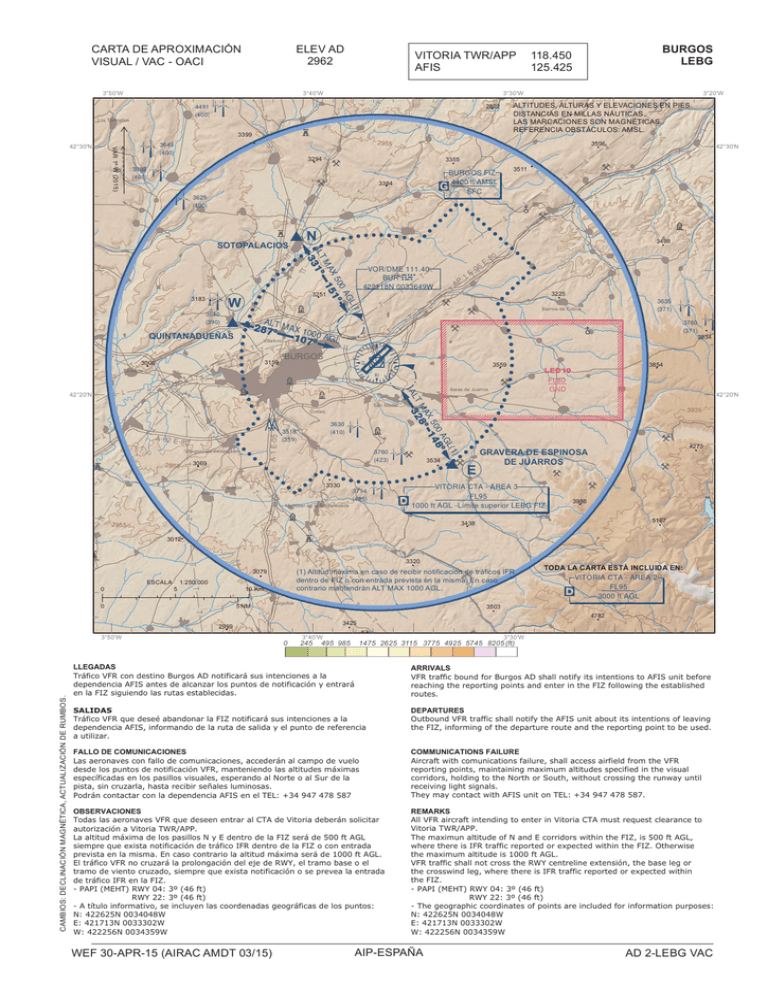
¼ ¼ ELEV AD 2962 CARTA DE APROXIMACIÓN VISUAL / VAC - OACI 3°50'W 4491 (400) Los Tremellos A 3399 3648 (400) 3602 (400) ! A-1 E-05 3069 SS 3630 (410) 3518 (359) 3330 Villariezo Modúbar de la Emparedada 0 CAMBIOS: DECLINACIÓN MAGNÉTICA, ACTUALIZACIÓN DE RUMBOS. Ä SS¼ SS ESCALA 5 Ibeas de Juarros ¼ 0 42°20'N ¼ GRAVERA DE ESPINOSA DE JUARROS ¼ VITORIA CTA - AREA 3 FL95 D 1000 ft AGL -Límite superior LEBG FIZ 3986 5167 3438 3°40'W 495 985 ¼ ¼1475 ¼ 4273 ¼ ¼ 3503 245 3854 3935 TODA LA CARTA ESTÁ INCLUIDA EN: VITORIA CTA - AREA 2 FL95 3000 ft AGL D 4782 3425 2999 SS 3°30'W 2625 3115 3775 4925 5745 8205 (ft) LLEGADAS Tráfico VFR con destino Burgos AD notificará sus intenciones a la dependencia AFIS antes de alcanzar los puntos de notificación y entrará en la FIZ siguiendo las rutas establecidas. ¼ ARRIVALS VFR traffic bound for Burgos AD shall notify its intentions to AFIS unit before reaching the reporting points and enter in the FIZ following the established ¼ ¼¼ routes. ¼ SALIDAS Tráfico VFR que deseé abandonar la FIZ notificará sus intenciones a la dependencia AFIS, informando de la ruta de salida y el punto de referencia a utilizar. ¼ A DEPARTURES Outbound VFR traffic shall notify Äthe AFIS unit about its intentions of leaving the FIZ, informing of the departure route and the reporting point to be used. FALLO DE COMUNICACIONES Las aeronaves con fallo de comunicaciones, accederán al campo de vuelo desde los puntos de notificación VFR, manteniendo las altitudes máximas específicadas en los pasillos visuales, esperando al Norte o al Sur de la pista, sin cruzarla, hasta recibir señales luminosas. Podrán contactar con la dependencia AFIS en el TEL: +34 947 478 587 COMMUNICATIONS FAILURE Aircraft with comunications failure, shall access airfield from the VFR reporting points, maintaining maximum altitudes specified in the visual corridors, holding to the North or South, without crossing the runway until receiving light signals. They may contact with AFIS unit on TEL: +34 947 478 587. OBSERVACIONES Todas las aeronaves VFR que deseen entrar al CTA de Vitoria deberán solicitar autorización a Vitoria TWR/APP. La altitud máxima de los pasillos N y E dentro de la FIZ será de 500 ft AGL siempre que exista notificación de tráfico IFR dentro de la FIZ o con entrada prevista en la misma. En caso contrario la altitud máxima será de 1000 ft AGL. El tráfico VFR no cruzará la prolongación del eje de RWY, el tramo base o el tramo de viento cruzado, siempre que exista notificación o se prevea la entrada de tráfico IFR en la FIZ. - PAPI (MEHT) RWY 04: 3º (46 ft) RWY 22: 3º (46 ft) - A título informativo, se incluyen las coordenadas geográficas de los puntos: N: 422625N 0034048W E: 421713N 0033302W W: 422256N 0034359W REMARKS All VFR aircraft intending to enter in Vitoria CTA must request clearance to Vitoria TWR/APP. The maximun altitude of N and E corridors within the FIZ, is 500 ft AGL, where there is IFR traffic reported or expected within the FIZ. Otherwise the maximum altitude is 1000 ft AGL. VFR traffic shall not cross the RWY centreline extensión, the base leg or the crosswind leg, where there is IFR traffic reported or expected within the FIZ. - PAPI (MEHT) RWY 04: 3º (46 ft) RWY 22: 3º (46 ft) - The geographic coordinates of points are included for information purposes: N: 422625N 0034048W E: 421713N 0033302W W: 422256N 0034359W WEF 30-APR-15 (AIRAC AMDT 03/15) AIP-ESPAÑA G 3760 (371) 3834 LED10 FL80 GND E¼( E Cogollos SS Ä 3559 3534 3635 (371) Barrios de Colina 3320 10 Km 5 NM ¼ 80 (1) Altitud máxima en caso de recibir notificación de tráficos IFR dentro de FIZ o con entrada prevista en la misma. En caso contrario mantendrán ALT MAX 1000 AGL. 3079 1:250.000 E- ¼ A 0 3°50'W 3794 (425) 5 ¼ ¾ 3012 A ¾ 3760 (423) 2955 ¾ 3225 â Villagonzalo Pedernales San Medel Cortes 1 0 E- (1) GL 0 A 8º 5 0 14 AX º T M 28 AL 3 A-62 E -80 Arcos [ ¾ º̄¯ 2955 ° BURGOS ¾ ¾ 42°20'N ¼ â â 3159 3006 ¼ â AL 287 T MAX 10 º 10700 AGL Villatoro º â Tardajos AP â ¾ VOR/DME 111.40 BUR 422118N 0033649W BUR 3251 E QUINTANADUEÑAS ¼ G 3498 (1) GL 0A 5 0 1º AX 15 TM AL 31º 3 2955 3540 (390) 42°30'N ¼ 3511 BURGOS FIZ 4400 ft AMSL SFC 3384 N E( SS( W ¼ ¼ Ä 3183 A 3°20'W 3596 3629 (400) SOTOPALACIOS BURGOS LEBG ALTITUDES, ALTURAS Y ELEVACIONES EN PIES. DISTANCIAS EN MILLAS NÁUTICAS. LAS MARCACIONES SON MAGNÉTICAS. REFERENCIA OBSTÁCULOS: AMSL. 3355 ¼ A Ä 2955 3294 SS 118.450 125.425 3°30'W 2802 â VAR 1º W (2015) SS SS 3°40'W SS â ×Ø 42°30'N VITORIA TWR/APP AFIS AD 2-LEBG VAC IN NC IN ION TE AD NT A IO ME NA NT LL E Y EN BL B AN LA K NC TE O
